
Forecast Updated on Monday, February 10, 2025, at 3:30am by WBOC Chief Meteorologist Mike Lichniak.
Today: A few flurries and rain showers possible early in the morning. Otherwise, it will be partly to mostly sunny. Highs: 40-45. Winds: N-NW 5-15 mph.
Tonight: Partly to mostly cloudy. Lows: 25-32. Winds: N-NE 5-15 mph.
Tuesday: Mostly cloudy with snow arriving by late morning early afternoon. Snow becomes heavy at times into the evening hours for some. Snow mixes in sleet / rain farther south. Highs: 28-34. Winds: E-NE 5-15 mph.
Tuesday Night: Periods of snow, heavy at times across parts of the area. Still looking at a mix of sleet / rain across southern parts of Delmarva. Lows: 28-34. Winds: NE-N 5-20+ mph.
Wednesday: Lingering snow showers to start the day as the storm departs. It turns partly to mostly cloudy for the afternoon hours. Highs: 35-42. Winds: NE-SE 5-20+ mph.
Thursday: On and off rain, heavy at times. Windy. Highs: 50-58. Winds: S-SW 10-25+ mph.
Watching a little system pass by to our south this morning, but with enough moisture making it up to the north that we are seeing some flurries and showers across parts of the area. This will start to taper off as we work into the morning hours as today will be the calm before the storm. We will see a mix of sun and clouds with temperatures in the 40s for highs before we start to see the clouds on the increase throughout the night ahead of our next winter storm of the season.
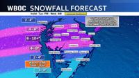
The snow will start to fly across Delmarva by the late morning or early afternoon hours of Tuesday. As the moisture overspreads the area and the low begins to develop just to our south, the intensity of the snow will start to pick up into the later afternoon and evening hours. We are looking for a band of snow to set up across northern and central Delmarva where we are looking at possible snowfall rates over 1” per hour for several hours into the evening hours.

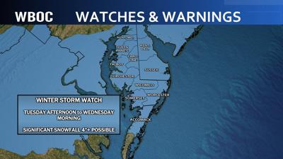
With our heaviest snow falling in the evening and early in the overnight, we will see a significant snow storm across a good part of Delmarva where the majority of us will see somewhere between 4-8” of snow with some locally heavier amounts possible. The farther south you go of Salisbury will need to watch for the mix in sleet or rain with this system as some warmer air will get pulled into this part of the region and will limit snowfall totals across the southern 3rd. The farther north you go across Delmarva will see limiting snow totals because the moisture will not reach too far north past Dover. So, as you move north of Dover…the cut off of snow will start to become drastic as well. The storm will taper off into Wednesday morning providing a break for Wednesday from precipitation.
Warmer air will surge in for Wednesday night and Thursday and will drive our temperatures into the 50s on Thursday on a strong southerly breeze. This will be ahead of another low that develops to our west and cuts to our north. This will put us on the warm side of this storm and it will be a mainly rain event. This will also help out with the snow melt and the majority of what falls during the day on Tuesday and Tuesday night will be gone by Friday. If it isn’t, it will be by the weekend as we forecast temperatures in the 50s on Saturday and Sunday but with more rain chances.