Snow will taper off and end this evening but skies will remain cloudy late. Very cold. Low 19F. Winds N at 5 to 10 mph. Chance of snow 100%. Snow accumulating 1 to 3 inches..
Tonight
Snow will taper off and end this evening but skies will remain cloudy late. Very cold. Low 19F. Winds N at 5 to 10 mph. Chance of snow 100%. Snow accumulating 1 to 3 inches.
...BLOWOUT TIDES CONTINUE THROUGH TONIGHT...
Continued northwesterly winds have kept water levels lower than
normal. In particular, most locations across the tidal Potomac and
western shores of the Chesapeake Bay are reporting water levels
around 1 to 1.5 feet below mean lower low water. Some rebound is
expected tonight for some sites, but some areas won't improve
until Thursday morning or afternoon.
Mariners should check navigation charts and be careful not to
ground your vessel, particularly when boating away from the main
channel.
Weather Alert
...WINTER STORM WARNING REMAINS IN EFFECT UNTIL 6 PM EST THURSDAY...
* WHAT...Heavy snow. Additional snow accumulations between 1 and 3
inches.
* WHERE...Inland Worcester, Maryland Beaches, Somerset, and Wicomico
Counties.
* WHEN...Until 6 PM EST Thursday.
* IMPACTS...Plan on slippery road conditions. The hazardous
conditions will impact the Wednesday evening and Thursday morning
commutes.
PRECAUTIONARY/PREPAREDNESS ACTIONS...
If you must travel, keep an extra flashlight, food, and water in
your vehicle in case of an emergency. Call 511 for road information.
&&
Weather Alert
...SMALL CRAFT ADVISORY REMAINS IN EFFECT FROM 10 PM THIS EVENING
TO 1 PM EST THURSDAY...
...GALE WARNING REMAINS IN EFFECT FROM 1 PM THURSDAY TO 10 AM EST
FRIDAY...
* WHAT...For the Small Craft Advisory, north winds 10 to 20 kt
with gusts up to 25 kt expected. For the Gale Warning,
northwest winds 15 to 25 kt with gusts up to 40 kt and waves 2
to 4 ft expected.
* WHERE...Chesapeake Bay main channel north of Smith Point VA,
Tidal Potomac from Cobb Island MD to Smith Point VA, Chester
River to Queenstown MD, Eastern Bay, Choptank River to
Cambridge MD and the Little Choptank River, and Tangier Sound
and the inland waters surrounding Bloodsworth Island.
* WHEN...For the Small Craft Advisory, from 10 PM this evening
to 1 PM EST Thursday. For the Gale Warning, from 1 PM Thursday
to 10 AM EST Friday.
* IMPACTS...Strong winds will cause hazardous waves which could
capsize or damage vessels.
PRECAUTIONARY/PREPAREDNESS ACTIONS...
Mariners should alter plans to avoid these hazardous conditions.
Remain in port, seek safe harbor, alter course, and/or secure the
vessel for hazardous conditions.
&&
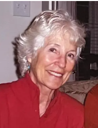
Betsy Bowen Rogan, 92, of Berlin, MD, passed away peacefully on Monday, February 10th, surrounded by her loved ones. Betsy was born in Salisbury, MD, to Irene Freeman Bowen and Wilmer Bishop Bowen.