DELMARVA - Alongside beautiful scenery, winter weather brings challenges to our roadways. To help travelers plan routes during the snow, Delaware, Maryland, and Virginia offer interactive snow plow tracking maps on their respective Departments of Transportation websites.
How the maps work
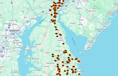
Delaware's snow plow tracker updates every 60 seconds with snow plow activity across the First State. It shows plows that are on the move and those that are currently stationary, which allows users to estimate how recently the roads near them have been cleared.
The plow tracker map layer was developed years ago to help reduce phone calls and demonstrate progress made during a storm. If most plows are on main roads, DelDOT is still in early operations, but if they're on local and back roads, things may be wrapping up.
How to access the maps
Visit DelDOT.gov/map. In map layers, select snow plow tracking. You can also track snow plows on Maryland's website here and in Virginia here.
Additional resources
DelDOT's interactive map includes a great deal of information in different layers, including traffic cameras, surface conditions, driving restrictions, the locations of vehicle charging stations and more.