

DELAWARE- A new era of school safety has made its way to the First State.
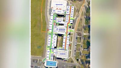
Delaware's Emergency Management Agency (DEMA) now has high definition maps of the state's 238 public and charter schools.
The maps are meant to help first responders be more efficient during emergencies, and the project is a joint effort between DEMA and a New Jersey based company, Critical Response Group (CRG).
CRG creates military inspired grid maps of schools, and CEO Michael Rodgers tells us they are being used across the nation. Although, Delaware is the first state to have the maps for all of its schools.
Rodgers came up with the idea after working in special operations with the U.S. Army.
"It kind of just started as an idea to take a lesson learned on the battle field and apply it," he said. "We took the gridding technique that the military uses to make very simple, accurate maps that can be placed directly into the systems that public safety professionals are already comfortable using."
Head of DEMA's Comprehensive School Safety Program, Doug Scheer, said the project was born out of necessity.
"The old maps are outdated and our first responders did not have the floor plans," Scheer said. "In order for them to see floor plans they had to physically log into a different website, download and send it out to somebody who is on the road. That is too many steps in a time of need."
Scheer said the maps are not only for active shooter scenarios either.
"If you have a tornado or a building collapse you are going to need to know where everything is and who could be the vulnerable population in those areas," he said. Also noting how the maps can be used for evacuation plans, and during public health emergencies.
Both Rodgers and Scheer compared the maps to a game of battlefield, and said they are easy for anyone to comprehend.
However, only first responders and schools administrators will have access to them.
CRG also has a maintenance program which will create updated maps if Delaware schools make layout changes in the future.